There is a running joke in my workplace that I am afraid of buoys – but it’s not really a joke. As physical objects I think they’re pretty scary; something to do with manmade objects attached to the ocean floor… but recently a coworker said something along the lines of “oh, Nick hates buoys,” and I realized I had totally misrepresented my feelings!
I might be scared of buoys as physical object, but buoyage as a system is totally brilliant. In the United States, buoys follow a consistent, redundant set of design patterns that allow unambiguous position-finding and maritime navigation. In this article I would like to give a short introduction to buoys and some other maritime navigation aids such as daymarks and light stations, as well as a short rundown of the ways that these navigation aids are denoted on nautical charts.
Most of my experience with maritime navigation has been in the San Juan islands leading multi-day sailing trips with children. We don’t carry GPS devices, and our boats are open-cabin sailing vessels, meaning a compass, a pencil, and a paper chart are usually all the navigation tools we have. The San Juan Islands are an archipelago where visual navigation is completely possible if you are familiar with the area, but there’s something about being able to cross-reference what you’re physically seeing with a paper chart that feels very exciting.
As someone who is fond of systems thinking, maritime navigation just feels incredibly pleasing to me, and I hope I can share a little bit of that excitement with you.
First, what are buoys for?
Buoys are used in two main ways: as a navigation aid, and as hazard markers. Coastal and inland waterways can be extremely variable in depth – certain channels are dredged to allow for navigation only via a certain path, and underwater structures such as kelp beds, variations in the sea floor, and manmade submerged equipment can present a hazard to mariners that would not be visible by looking at the surface of the water.
Buoys (combined with other navigation aids) provide markers of safe passage, but the system encodes much more detailed information than just that. By observing maritime navigation aids, a mariner can quickly find their position on a chart, discern the preferred direction of travel, note underwater hazards, and determine which direction is up-/down-channel (into or away from a bay or up a river). All of this information is encoded using multiple physical qualities of each buoy.
Nuns and Cans
The shape, color, and numbers displayed on the side of buoys create a redundant system to indicate to mariners the “preferred channel” of travel. There are two main types of buoys that mark the boundaries of a channel.
“Cans” are cylindrical, green, and are marked with odd numbers. Cans should be kept to the port side of your vessel when entering from seaward, or when proceeding upriver. “Nuns” are conical, red, and are marked with even numbers. Nuns should be kept to the starboard side of your vessel when entering from seaward, or when proceeding upriver. The mnemonic “red, right, returning” is frequently used to remember that one should keep red buoys on the starboard side when entering a harbor, but the longer mnemonic “even red nuns carry odd green cans” encodes all three pieces of information.
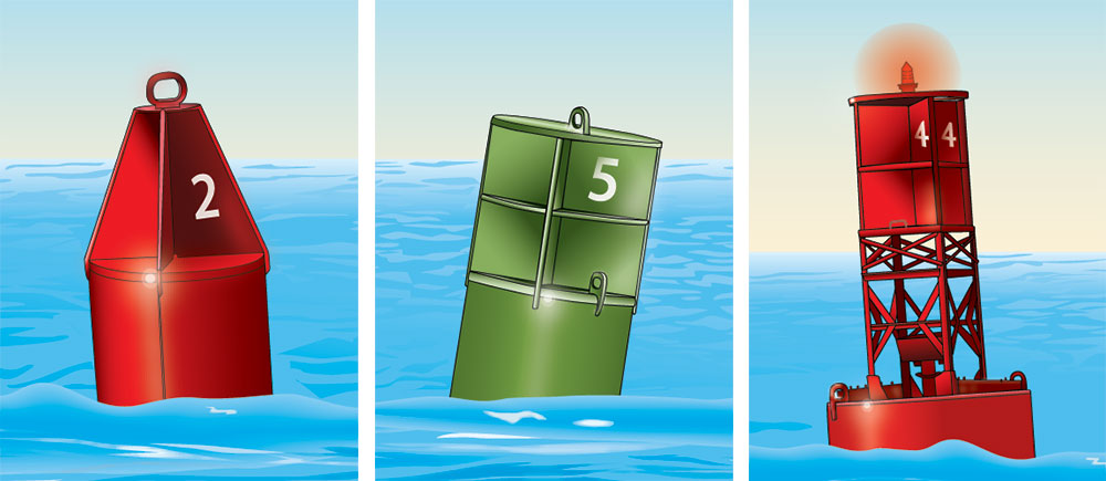
These buoys will also follow an increasing numbering scheme as you travel into a harbor or upstream. This means that if you are following a channel, you actually have four redundant pieces of information to help you navigate.
Hazard and Preferred Channel Markers
Some buoys sit in the middle of preferred channels rather than along the sides. These buoys will be both red and green, but the color on top indicates the direction of preferred passage. If the buoy is red-green-red (from bottom to top), you should keep the buoy to the right of your vessel when entering a harbor or proceeding upstream.
Buoys that indicate the middle of preferred channels will display numbers rather than letters.
Charts and Light Signals
One of the greatest things about the information encoded in the design (color, shape, numbering, lighting) of buoys is how efficiently that information can be encoded on a nautical chart. This enables mariners to engage in piloting (navigation by visual reference and charts) by quickly referencing their surroundings to the chart, and vice versa. Buoys in proximity to each other will have distinct lighting or coloring patterns so they can be easily disambiguated.

The “Danger Shl” buoy is a later guidance marker that allow mariners to avoid a very shallow bit of water in an otherwise easily navigable area.
| Marking | Meaning |
|---|---|
| Split diamond-shaped icon | The buoy is multi-color, with green on top |
| Purple shading | The buoy has a light |
| Danger Shl | The name of the obstruction |
| GR | The buoy is green/red, with green on top |
| “A” | An “A” is painted on the side (also, the letter is a hint that this is a mid-channel lateral guidance buoy) |
| Fl (2+1) | The light pattern is “composite group-flashing” – two flashes, a pause, one flash, a pause |
| G | The light is green in color |
| 6s | The flashing pattern will repeat every 6 seconds |
Because this buoy is green/red (with green on top), it should be kept to the port side of the vessel when returning to harbor, or to the starboard side when progressing seaward. At night, it is unlikely that another green light with the composite group-flashing pattern noted would be present in the same vicinity, so it could be used to confirm one’s position with the use of the chart.
There are many other pieces of information that can be encoded on a nautical chart, and they are all explained in NOAA Chart No 1. If you buy a paper chart, most of them will also come with simple legends.
Learn More
I’ve just touched the surface of buoys and piloting, but there are lots more well-designed components of maritime navigation. If you’re interested, most states offer free boater education courses (such as this one for Washington state by BoatUS).
BoatUS also has a great article about aids to navigation which covers buoys (lateral navigation, hazard, safe water) as well as other types of aids such as daymarks.
All nautical charts and associated publications can be accessed for free at NOAA’s website.